


Land Navigation Course — 4-Day Master Navigator Training
Land Navigation Course — 4-Day Master Navigator Training
Choose Date and Location:
Choose Options:
Couldn't load pickup availability
Land Navigation Course — Map Reading and Land Navigation Training
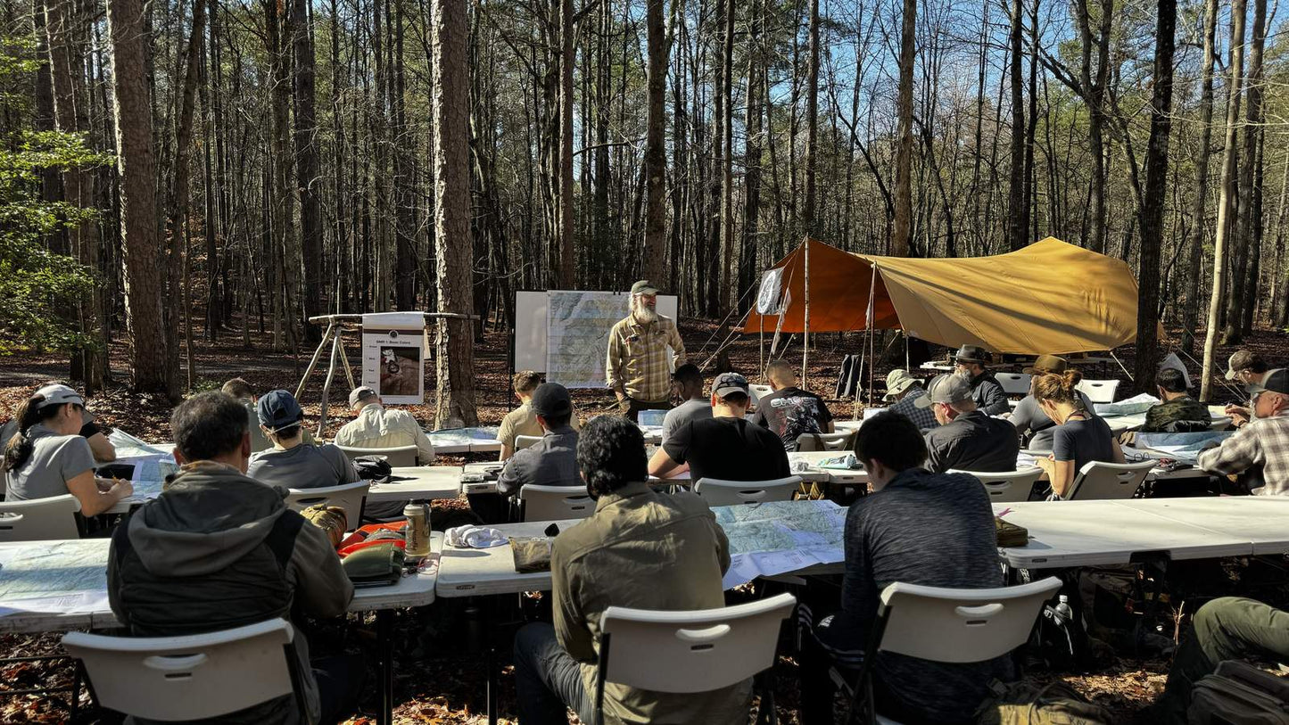
The Master Navigator™ Map Reading and Land Navigation Course is a 4-day, 3-night immersive field course covering the complete spectrum of map and compass skills — from basic map anatomy and declination adjustment through terrain association, dead reckoning, self-mapping, and night navigation. This land navigation training was developed and is taught by former Army Ranger and Green Beret Joshua Enyart, and is designed for anyone who wants to navigate any terrain, in any conditions, without depending on GPS or a phone signal.

Learn to Survive
Hardcover · Full Color · 430 Pages · by Joshua Enyart
Surviving the Wild is the recommended pre-course reading for GB2 students — 430 full-color pages covering the field survival skills that support extended time in the backcountry, the same environment you'll be navigating through over four days and three nights.
Get the Book →Why Land Navigation Training Matters
Navigation is the one skill where a single mistake doesn't give you a second chance to correct it. Getting turned around three miles from camp in failing light, or committing to the wrong drainage because you misread a contour line — those situations unfold fast and they compound. What separates the people who handle them from the ones who don't isn't luck or fitness. It's the ability to read ground against a map, stay oriented while moving, and know exactly what to do when the picture stops making sense.
The Master Navigator™ Course is that professional navigation training — built on the same structured progression Joshua applied during his service and has taught for three decades since: foundational theory to unsupervised field application, with enough repetition that the skills hold under fatigue and stress, not just in a classroom. You won't leave with a certificate that says you attended a land navigation course. You'll leave with the skills to back it up.
Why Four Days? The Case for Repetition
There are shorter land navigation courses out there. A motivated student can learn the theory of map reading and compass use in a single day. But knowing how something works and being able to do it under pressure, in unfamiliar terrain, in the dark, while tired — those are not the same thing, and no amount of classroom time closes that gap.
The Master Navigator™ Course is built around a minimum of six full navigation lanes that every student must complete. Not demos. Not group exercises where one person navigates and the rest follow. Six lanes — run in two-person teams for safety — where you are the one with the map, the compass, and the decision. That volume is not padding — it is the point. Navigation becomes a reliable skill through repetition, and repetition takes time. The four-day structure exists because that is genuinely what it takes to make a student good at this, and cutting it short would mean sending people home with familiarity instead of competence.
What You'll Learn in This Land Navigation Course
The Master Navigator™ curriculum follows the same crawl-walk-run instructional model used across the GB2 course lineup. Every skill is introduced, demonstrated, practiced under supervision, and then applied in a real-world field scenario before the course moves on. The four-day structure gives the curriculum enough time to run students through the complete skill set at a pace that builds genuine retention — not surface familiarity.
Map Anatomy and Topographic Reading
The course begins where all land navigation begins — with the map itself. Students work through the full anatomy of a topographic map: contour lines and what they tell you about terrain in three dimensions, grid systems and coordinate notation, map symbols and marginal data, and the relationship between map scale and the level of detail it captures. Most people who think they can read a map have learned to find their approximate location on a trail map. This section teaches you to read terrain — to look at a contour pattern and understand exactly what the ground is doing before you ever set foot on it.
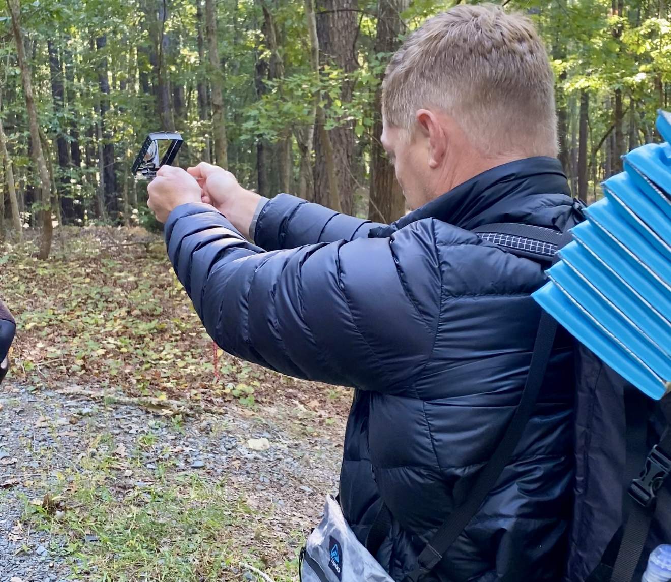
Declination Adjustment and Compass Mechanics
A compass that isn't corrected for magnetic declination will walk you off course without ever telling you it's happening. The course covers this in two stages. First, students learn to convert declination mathematically — adding or subtracting the declination value for their operating area to translate between magnetic and true north. This works on any compass, regardless of whether it has an adjustable declination feature, and it builds the foundational understanding of what declination actually is and why it matters. Second, students learn to set declination mechanically on compasses equipped with that feature — but only after the math makes clear what the adjustment is doing. A student who sets declination without understanding the conversion is operating a tool they don't fully understand. Students also work through the common errors in compass use — tilt and metal interference — so they know what failure looks like and how to correct it before it costs them distance.
Terrain Association and Dead Reckoning
Terrain association is navigation by visual confirmation — moving from identifiable feature to identifiable feature and checking your map position against what the ground is actually doing around you. Dead reckoning is navigation by math — tracking your direction of travel and distance covered to project your current position from a known starting point. Both are essential land navigation skills, and they work best together. The course teaches students to use them as a paired system: terrain association to confirm position, dead reckoning to bridge the gaps between confirmations.
Locating Unknown Points
Knowing your general area is not the same as knowing your precise position. This section covers the procedures for determining exactly where you are when you don't have a confirmed starting point — triangulation from identifiable landmarks, resection from two or more known points, and the systematic process for reorienting when the map and the ground stop matching. These are the land navigation skills that matter most when something has already gone wrong, and the goal is to always have a defined procedure for figuring out your position regardless of how you got there.
Self-Mapping
Self-Mapping is the skill of constructing a usable navigational reference from the ground up when no map is available or when the available map lacks the detail you need. It's a skill most land navigation courses don't teach because it sits above the standard curriculum — but it's exactly the capability that separates someone who can navigate when conditions are favorable from someone who can navigate in any conditions. Students learn the principles, the process, and the field-expedient tools that make it work.
Field-Expedient Direction Finding
The course covers solar, lunar, and celestial direction finding in depth — not as curiosities, but as functional backup systems for compass navigation. Students learn shadow-tip methods, sun azimuths, and star navigation with enough procedural clarity that the techniques are usable in the field rather than just recognizable from a book. Understanding how these systems work also reinforces the underlying principles of azimuth navigation that govern all compass work — which is why the course covers them as a full curriculum block rather than an afterthought.
Night Navigation
Night navigation is where the full skill set gets tested. The course includes night navigation exercises that take everything covered during daylight hours and require students to apply it in low-light and no-light conditions. Terrain association is harder at night. Compass reading requires discipline. Pace counting becomes the primary distance tool when visual confirmation of the ground disappears. Night navigation is where land navigation training consolidates — where you find out what you've actually internalized versus what you were relying on the environment to confirm for you.
Pace Counting and Distance Estimation
Pace counting is the foundational tool for dead reckoning, and the course treats it accordingly. Students establish their personal pace count across varied terrain — flat ground, slope, heavy brush — and learn to apply that data to movement planning and position tracking. Distance estimation covers how to cross-check pace count data against terrain features and map scale to maintain a reliable running position estimate as you move through the course.
Land Navigation Course Online — Study Before You Attend
If you want to study the curriculum before your live course date, or if you're looking for a digital-only option, the Master Navigator™ instructional series is available in full on the GB2 Network. The online course covers the same foundational material — map reading, compass mechanics, terrain association, dead reckoning, self-mapping, and field-expedient direction finding — in a structured video format you can work through at your own pace. Access the Master Navigator™ Course on the GB2 Network here.
Instructor Credentials and Safety Infrastructure
The Master Navigator™ Course was developed by Joshua Enyart — a former Army Ranger and Green Beret with three decades of professional instructor experience. The curriculum reflects the methodological standards Joshua was held to during his service and has applied consistently in civilian instruction since: a specific, sequenced progression that builds functional competence rather than surface familiarity. Students who have taken land navigation courses elsewhere frequently note that the Master Navigator™ curriculum covers more ground and more depth than anything they encountered before — because it was built on a professional training standard, not a recreational one.
Every GB2 course site operates with an on-site Medic Station staffed with a dedicated medic and SAR (Search and Rescue) personnel. All instructors are CPR/AED certified and Wilderness First Responder certified at minimum. The course is fully insured, and every safety protocol reflects what responsible field instruction actually requires.
Who This Land Navigation Course Is For
The Master Navigator™ Course is built for civilians who want to navigate without depending on technology — hunters, hikers, backpackers, overlanders, search and rescue volunteers, outdoor professionals, and anyone else who operates in terrain where a dead battery or lost signal has real consequences. No prior land navigation experience is required. The crawl-walk-run structure is designed to bring complete beginners through to functional competence across the four-day curriculum.
Students with prior experience — from other navigation courses, military service, or years of backcountry travel — consistently find that the Master Navigator™ framework approach reorganizes and deepens what they already know. The curriculum doesn't just teach techniques; it teaches the underlying logic that makes those techniques work across conditions and environments they haven't trained in before.
How This Course Fits the GB2 Curriculum
The Master Navigator™ Course is the live course through which the GB2 System of Training™ delivers its civilian land navigation curriculum — the dedicated four-day deep dive into one of the 8 Survival Priorities. Students who want a foundational field course covering all 8 priorities before adding depth in specific areas should start with the Wilderness Survival Course — 3-Day Foundation Training. Students who want written reference material to study before or after the live course should look at the Master Navigator™ PDF Series: Complete Bundle (Parts 1–8) — eight structured study guides covering every topic in the live curriculum. For a comprehensive field reference across all 8 Survival Priorities, Joshua's book Surviving the Wild covers the full methodology in a single volume.
Event Status and Travel Policy
Courses listed as "Scheduled" are planned events pending minimum enrollment. Once minimum enrollment is reached, the status changes to "Confirmed" and the course is guaranteed to run. "Confirmed – Limited" indicates only a few seats remain. Students are advised to make travel arrangements only after a course is marked Confirmed. Gray Bearded Green Beret LLC is not responsible for airfare, lodging, rental vehicles, or other travel expenses in the event a Scheduled course does not meet minimum enrollment or must be rescheduled due to circumstances beyond our control.
Course Details and Packing List
The Master Navigator™ Course runs 4 days and 3 nights in a field environment. Multiple dates and locations are available — check current listings for the schedule nearest you. A full packing list covering required and recommended gear is available for download before you register: Master Navigator™ Course Packing List. Physical fitness is required — the course includes multi-kilometer ruck marches and extended field time under load. Recommended gear is listed in the Master Navigator Course Gear collection.
Frequently Asked Questions
What will I be able to do after completing the 4-Day Master Navigator Course?
By the end of the 4-Day Master Navigator Course, you'll be able to read a topographic map, orient it to terrain, plan and execute a land navigation route using map and compass, locate your position using terrain association and grid coordinates, and navigate in daylight and reduced visibility. You'll leave with the same foundational land navigation skills taught in U.S. Army Special Forces selection programs — applied to civilian wilderness and backcountry use.
Do I need any prior map reading or compass experience?
No prior experience is required. The course begins at the foundation — map anatomy, how topographic lines represent terrain, and basic compass operation — and builds progressively through four days of combined classroom instruction and field application. Students with existing skills will refine and formalize their technique; complete beginners will develop a solid, functional skill set.
What gear do I need to bring?
The packing list is linked in the product description above — review it before registering. Upon registration you'll also receive the Student Coordination Packet with full logistics and everything you need to prepare.
What is the student-to-instructor ratio?
GB2 maintains a maximum of 4–6 students per instructor across every course. That ratio is intentional — it ensures every student receives direct, hands-on feedback during field exercises rather than getting lost in a large group.
Is this course appropriate for military veterans, active duty, law enforcement, or civilians?
Yes to all of the above. The curriculum covers proven land navigation techniques scaled for civilian wilderness application, but it's equally relevant for military and law enforcement preparation. A significant number of GB2 students use this course specifically to train for Special Operations selection courses — including SFAS (Special Forces Assessment and Selection) and other military and federal selection pipelines where land navigation is a gated requirement. Regardless of your background, the field exercises are the same — navigation is navigation.
Does the course include the Master Navigator PDF Series?
The Master Navigator PDF Series is strongly recommended as pre-course study material — students who work through it before arrival consistently perform better in day-one field exercises because the conceptual framework is already in place. The PDF Series is a separate purchase available on the GB2 store. Protractors, field maps, and all instructional materials used during the course are provided.
What happens if weather or conditions force a schedule change?
Field training courses operate in realistic conditions by design — weather is part of the training environment. In the rare event that conditions create genuine safety concerns, the instructional team will adjust the schedule accordingly. You'll receive communication directly from the GB2 team. Rescheduling policies are detailed in the registration agreement.